2025 Summer and Atlantic Hurricane Season Outlooks
2025 summer outlook:
11:30 a.m. Thursday, May 29, 2025:
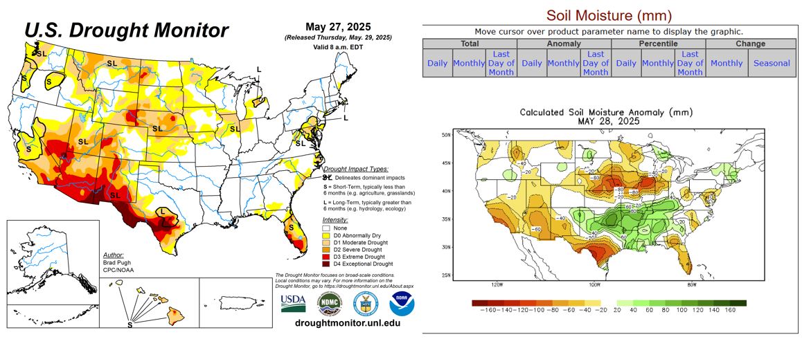
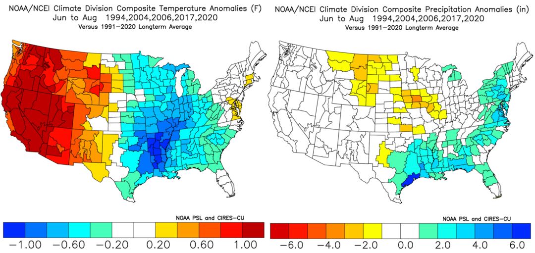
In stark contrast to 2024, searing heat could make far fewer appearances across the Northeast and mid-Atlantic States this summer. Historical analogs.. or previous years with similar, large-scale patterns and teleconnection signals.. support the idea of a "backend summer" with above-normal rainfall and a near- to slightly-below normal number of 90-degree days. We are currently in a state of neither La Niña or El Niño conditions, and these "ENSO-neutral" conditions are expected to last into the fall. In the past 25 years, 1994, 2004, 2006, 2017 and 2020 featured ENSO-neutral conditions and a neutral or slightly-negative Pacific Decadal Oscillation (PDO) between the spring and autumn months. Thus, those 5 summers are my "analog years" for summer 2025. Things may get off to a slow start (in terms of heat) through early July. There is often a correlation between drought/soil moisture and extreme heat in the summer months. As of May 27th, the only parts of the nation experiencing significant drought were the Florida Peninsula, southwestern Texas, the north-central Plains, Four Corners region and northern Rockies. Soil moisture was most below normal in these regions and the Midwest, as well (see below). Thus, I expect the core of the heat to be across the Rockies, Four Corners region and Pacific Northwest this summer with "near-normal" temperatures in the Northeast and mid-Atlantic States. In between, aggregate temperatures will likely average "below normal" across the Deep South, Ohio Valley, Midwest and western Great Lakes region. June and early July, in particular, should be quite temperature across the mid-Atlantic States with high temperatures between 75-90°F on most days. Frequent disturbances and cold frontal passages will limit both the intensity and duration of any heat but also cause an active start to the summer in terms of showers, thunderstorms and severe weather. Many parts of northern MD, southeastern PA and the Lower Susquehanna Valley received 2-3 months' worth of rain between May 3-31, and the active/wet pattern will likely stick around through the first half of summer. Compared to May, I don't expect precipitation anomalies to be nearly as high in June or July, but rainfall will still likely be "above normal" during those two months.
During the second half of summer, I expect a hotter and drier pattern to develop across the Eastern States. The "Bermuda High".. or a semi-permanent area of high pressure that often develops near Bermuda during the "dog days" of summer.. should strengthen in mid-to-late July and pump more heat and humidity into the mid-Atlantic States through the end of August or early September. Diurnal showers and thunderstorms may still be quite common during this time due to the heat and humidity, but they should be more widely scattered and less frequent, generally speaking, compared to June and early July. Air conditioners probably won't get much of a workout through early July, but that could change later on as cooling demands increase dramatically later in July and August. Peak temperatures this summer should be at least several degrees lower than in 2024, but high humidity will accompany some of this summer's heatwaves and cause heat index values to be much higher than the actual air temperature. On some days, it may even be "dangerously hot" outside. Thus, it will be imperative to follow heat preparedness tips and advice given in my Special Weather Discussions (SWDs) and on Twitter(X) (@MUweather) throughout the summer. In terms of 90-degree days, I expect 10-20 of them (about half of last year) with a low probability of 100-degree heat. Millersville University averages 23, 90-degree days each year, so that number will likely be just a bit below normal in 2025. Relative to average, the "coolest and wettest" month of the summer should be June with August being the "hottest and driest." In aggregate, I expect temperatures from June through August to be "near normal" (+0-2°F) but with a hotter (+1-3°F) August. As a whole, rainfall will likely be "above normal" across the southern and eastern United States this summer (see below). -- Elliott
2025 atlantic hurricane season outlook:
11:30 a.m. Thursday, May 29, 2025:
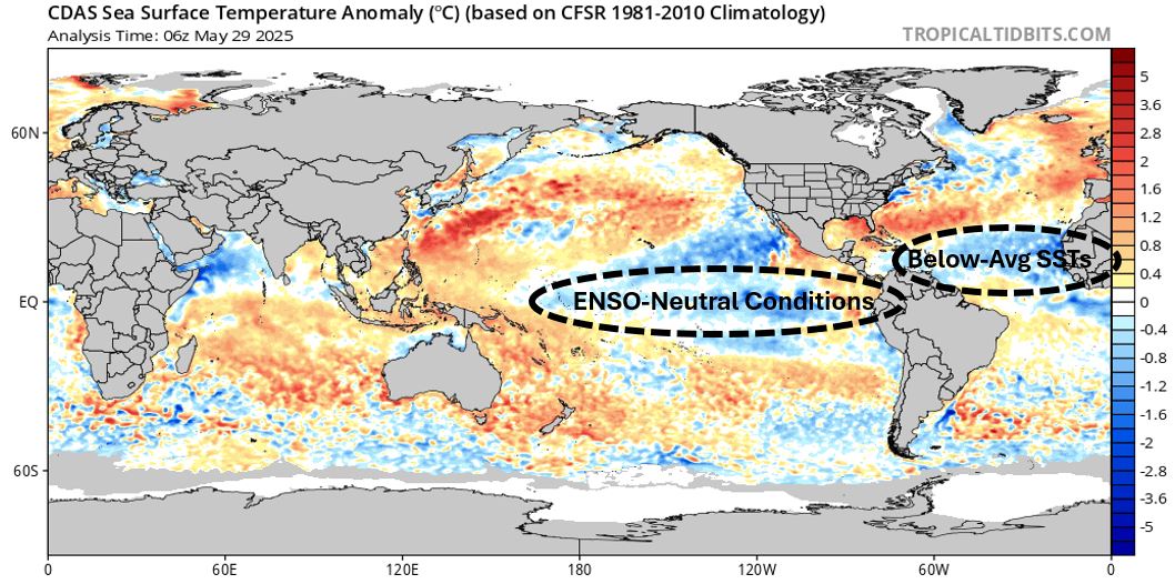
June 1st marks both the start of meteorological summer and the 2025 Atlantic Hurricane Season. As mentioned above, ENSO-neutral conditions are present in the equatorial Pacific and expected to persist through the fall. As a result, wind shear.. or the change in wind direction and/or speed with height above the ground.. should be near- to slightly-below normal in both the Atlantic and Pacific Basins this season. During El Niño, the southern branch of the Jet Stream typically becomes dominant over the northern branch. As a result, easterly trade winds in the tropics weaken and can even become westerly in the mid- and upper-levels of the atmosphere. During La Niña, the opposite is true, with an enhancement in easterly trade winds and weakening of the Jet Stream's southern branch. During ENSO-neutral conditions, wind shear in the tropics is often somewhere in between, or closer to average. Unlike severe thunderstorms, wind shear is detrimental to tropical storm and hurricane formation. So, less shear and stronger easterly trade winds support more tropical activity and an above-average number of named tropical cyclones. This season, the "average" amounts of shear and frequent, dry air intrusions from the Sahara Desert over the main development region (MDL) of the tropical Atlantic could lead to a relatively slow start to the season and "near normal" number of named storms overall. In addition, sea surface temperatures (SSTs) as of May 29th were well above normal across the Gulf of Mexico, southwestern Atlantic (the Bahamas) and northwestern Caribbean Sea but below average throughout the MDL (see below). Hurricanes behave like giant heat engines that use warm, moist air as fuel. Warmer-than-normal SSTs provide the additional fuel necessary for frequent storms and rapid intensification. Thus, I expect a number of storms to develop close to home this season and keep residents along the Gulf- and Southeastern U.S. coastlines uneasy and on high alert. Tropical activity should "heat up" later in August, September and October, but this is quite normal in terms of tropical storm and hurricane climatology.
 Due to the factors outlined above, I expect the 2025 Atlantic Hurricane Season to be "near average" with:
- 14-18 NAMED STORMS
- 6-10 HURRICANES
- 2-4 MAJOR HURRICANES (Category 3 or higher)
Unfortunately, I expect at least a few of those storms to make a direct landfall in the United States with a higher-than-normal chance of catastrophic impacts. Residents along both the Gulf- and Southeast Coasts from Texas to Florida and the Carolinas may all be at risk this season and should prepare now for the worst-case scenario of a direct hit. For information on hurricane preparedness, visit the National Hurricane Center's website, your local National Weather Service Forecast Office's website or other emergency management resources. In terms of the number of named storms, this season may be slightly less active than in 2024, but impacts to lives and property may be similar due to a number of "homegrown" systems in the Gulf, southwestern Atlantic and Caribbean Sea. Much like last season, I don't have a good feeling about this one, either. As an FYI, I'll keep these outlooks available until November 1st. Let's see how I do! -- Elliott