2026 Summer and Atlantic Hurricane Season Outlooks
2026 summer outlook:
12:00 p.m. Thursday, May 28, 2026:
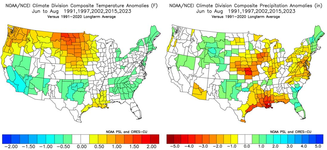
In stark contrast to 2025, this summer will start out "slow" in terms of 90-degree heat but ramp up significantly during the second half of the season. Historical analogs.. or previous years with similar, large-scale patterns and teleconnection signals.. support the idea of a "backend summer" with below-normal rainfall and an above-average number of 90-degree days. We are currently in a state of neither La Niña or El Niño.. i.e. "ENSO-neutral" conditions.. but El Niño should emerge and officially be declared in June or July and then strengthen through the late-summer and autumn months. In the past 35 years, 1991, 1997, 2002, 2015 and 2023 featured a quick transition from ENSO-neutral to El Niño conditions during the summer months, and three of those summers (1991, 2002 and 2023) featured a neutral or negative Pacific Decadal Oscillation (PDO). For reference, the PDO is currently negative but will likely trend toward neutral over the summer. Thus, those 5 summers are my "analog years" for summer 2026.
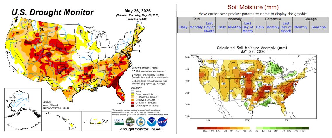
There is often a correlation between drought/soil moisture and extreme heat in the summer months. As of May 28th, a large part of the nation was being impacted by drought conditions. Nearly all of the Intermountain West and High Plains, as well as the Deep South, Southeast and southern mid-Atlantic States, were being ravaged by severe-to-extreme drought with pockets of exceptional drought. Soil moisture was most below normal in these regions and the Midwest, as well. Only in the Great Lakes region and Lower Mississippi Valley was soil moisture anomalously high (see below). Thus, I expect the core of the heat to be across the Rockies, Pacific Northwest, High Plains and Upper Midwest this summer with "near-normal" temperatures in the Great Lakes region and Northeast. Although an average of my five analog summers suggests cooler-than-normal conditions across the Southern States, I expect this summer to be an exception due to the widespread drought and dry ground. There may be some improvement in the drought during the second half of the season as a result of potential tropical systems and a more active southern Jet Stream, but aggregate temperatures will still likely end up slightly above normal from the southern mid-Atlantic States points south. However, June and early July, in particular, may be quite temperate across the mid-Atlantic States with only a few spurts of 90-degree heat across northern MD, southeastern PA and the Lower Susquehanna Valley.
After an abnormally dry first 1-2 weeks of June, frequent disturbances and cold frontal passages from mid-June through early-to-mid July will limit both the intensity and duration of any heat but also cause an active start to the summer in terms of showers, thunderstorms and severe weather. A slow-moving storm system and smaller, subsequent disturbances dumped 2-5" of rain across a good portion of the mid-Atlantic States over the past week. However, that was an anomaly in an otherwise dry pattern since last autumn, and dry conditions will resume in the days and weeks to come. Thus, any additional showers and thunderstorms from mid-June through early-to-mid July will be largely beneficial. Overall, rainfall may average "near normal" from mid-June through early-July, but drier conditions will likely return by mid-July and persist through August. The "Bermuda High".. or a semi-permanent area of high pressure that often develops near Bermuda during the "dog days" of summer.. may briefly flare up from mid-July through early August, but much of our heat this season should be primarily of continental origin and come "over the top" instead of from the western Atlantic or Gulf of America. A semi-permanent "heat dome" will likely develop over the Rockies and High Plains, and northwesterly flow on its eastern periphery will direct some of that heat into the Ohio Valley and mid-Atlantic States at times. Fortunately, this means that a lot of our heat should be accompanied by low humidity, but any temperatures in the mid 90s to 100°F are dangerously high and make practicing heat safety essential. Another impact of the dry, northwesterly flow will be to limit diurnal showers and thunderstorms on days without cold frontal passages.. thus my expectation of a drier-than-normal second half of summer. I do not expect record dryness this summer, but overall rainfall should end up below average by a few to several inches. Given the ongoing moderate-to-severe drought, overall drier-than-normal weather may only exacerbate the situation and certainly won't allow for much, if any, improvement. As for heat, I anticipate an above-average number of 90-degree days this summer with near-normal odds for a 100-degree day. The highest temperature at the 'Ville in both 2024 and 2025 was 99°F, and I can see a similar outcome this year. Millersville University averages 23, 90-degree days each year, and I expect 25-35 of them in 2026. Based on my analogs, I expect aggregate temperatures from June through August to average 1-3°F above normal with seasonal rainfall deficits of 1-4" (see below). -- Elliott
2026 atlantic hurricane season outlook:
12:00 p.m. Thursday, May 28, 2026:
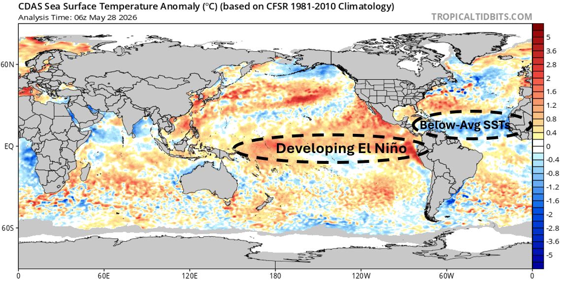
Not only does June 1st mark the beginning of meteorological summer, but it's also the start of the 2026 Atlantic Hurricane Season. Due to a developing and strengthening El Niño, wind shear.. or the change in wind speed and/or direction with height above the ground.. should be higher than normal in the Atlantic Basin this season. In El Niño patterns, the southern branch of the Jet Stream typically becomes dominant over and much stronger than the northern branch. As a result, easterly trade winds in the tropics weaken and can even turn westerly in the mid- and upper-levels of the atmosphere. Unlike severe thunderstorms, wind shear is detrimental to tropical storm and hurricane formation. Thus, more shear and weaker easterly trade winds support less tropical activity and fewer named systems. In addition, sea surface temperatures (SSTs) as of May 28th were slightly above normal across the Gulf of America, southwestern Atlantic (the Bahamas and Bermuda) and northwestern Caribbean Sea but well below average throughout the Main Development Region (MDL) (see below). Hurricanes behave like giant heat engines that use warm, moist air as fuel. Warmer-than-normal SSTs provide the additional fuel necessary for frequent storms and rapid intensification. Thus, I expect several storms to develop "close to home" this season, but they won't have much time to strengthen before making landfall along the Mexican, Gulf- or Southeastern U.S. coastlines. Tropical activity should "heat up" later in August, September and October, but this is quite normal in terms of tropical storm and hurricane climatology.
Due to the factors outlined above, I expect the 2026 Atlantic Hurricane Season to be "near- to slightly-below average" with:
- 11-15 NAMED STORMS
- 4-6 HURRICANES
- 2-4 MAJOR HURRICANES (Category 3 or higher)
I expect many of these systems.. especially the strongest ones.. to "recurve" back out into the open waters of the Atlantic with a lower-than-normal chance of a significant U.S. landfall. That being said, it only takes one major hit to make the season deadly and costly. For information on hurricane preparedness, visit the National Hurricane Center's website, your local National Weather Service Forecast Office's website or other emergency management resources. In terms of the number of named storms and U.S. impacts, this season may be quite similar to 2025. Fingers crossed! 🤞 As an FYI, I'll keep these outlooks available until November 1st. Let's see how I do! -- Elliott