2023-2024 Winter Outlook
Winter Seasonal Forecast by Kyle Elliott
* Basin-Wide El Nino to Enhance Risk of Major Snowstorm Late this Winter *
Friday, November 3, 2023:
2022-2023 ended as the least-snowy winter on record at Millersville University with a mere 0.9" of snow on the season. For much of the winter, it was simply too warm to snow. La Nina dominated the climate for the third-straight year and was largely responsible for the lack of cold and snow in the Lower Susquehanna Valley and along the I-95 corridor. By the middle of spring, La Nina finally faded. El Nino then emerged by the start of meteorological summer and has since strengthened through the middle of autumn. One of the main factors that influence both the weather and climate in the winter are ocean sea-surface temperature (SST) anomalies, or how much above- or below-normal the surface water temperature is, in the Pacific Ocean. When SST anomalies in the equatorial Pacific are above normal, we are in a state of El Nino. How high or low these anomalies are.. and where the most extreme anomalies are located.. dictate the strength and "base," respectively, of El Nino. When these anomalies are high and distributed equally across the equatorial Pacific, it is considered a "moderate-to-strong, basin-wide El Nino." This type of El Nino is currently present, and climate models agree on its persistence through the 2023-2024 winter season. Since 1970, there have been a host of these type of El Nino events. For the most part, temperature patterns during these winters have been relatively similar. In many of them, seasonal snowfall totals have ranged from 20-40" across the Lower Susquehanna Valley. However, one was the snowiest on record at Millersville, while two others produced less than 10" of seasonal snowfall. Thus, this winter will have at least some "boom or bust" potential.
Another key factor to consider in seasonal forecasting is the strength of the Stratospheric Polar Vortex (SPV). The SPV can play a major role in preventing or unleashing Arctic outbreaks across the central and eastern United States. When the SPV is strong and centered near the North Pole (as was the case last winter), cold air tends to remain bottled up in Arctic regions. When the SPV weakens, elongates, or splits into multiple pieces, bitter cold may plunge into the eastern U.S. and/or Europe just a few weeks later. One such split occurred in January 2021 and was at least partially responsible for the crippling ice storm and record cold that gripped the southern Plains (particularly Texas) in February. This year, the SPV should be strong through most of December, but there are factors already in place that could lead to a weakening of the vortex late in December or January. If the vortex does indeed become "unstable," then the door for cold air intrusions will be opened later in January and February.
The phase of the Pacific Decadal Oscillation (PDO) is yet another primary winter climate influencer. When SSTs are above normal in the interior North Pacific and below normal along the North American coast, the PDO has a negative value (see below). The opposite is true for a positive PDO. Since 2021, the PDO has been in a strong negative phase and is currently still in the same phase. However, it should gradually become less negative over the winter and may turn neutral or even slightly positive by February or March. Rarely does the PDO remain strongly negative throughout the duration of a moderate-to-strong El Nino winter. In negative PDO winters, the coldest winter weather (relative to normal) often occurs in the Pacific Northwest, northern Rockies, and northern Plains. In positive PDO winters, the coldest weather is favored across the central and/or eastern United States. Thus, the second half of this winter (post-January 15) presents the greatest risk of chilly air and any prolonged "cold waves."
(1/4) Alright, snow fans! The moment you've all been waiting for has arrived: my 2023-2024 Winter Outlook! Two primary winter-season influences will be our moderate-to-strong, basin-wide El Nino and negative Pacific Decadal Oscillation (PDO).. pic.twitter.com/Gqe77e7S03
— MU Weather Center (@MUweather) November 2, 2023
The last factor that I'll highlight is the Madden-Julian Oscillation (MJO). The MJO, which can be thought of as an eastward-moving area of convection between the Indian and central Pacific Oceans, can be active in 8 different phases. Each phase corresponds to a specific location of this tropical convection. Which phase the MJO is active in at any given time can alter weather patterns across North America on a week-to-week basis. Based on the location of highest SST anomalies between the Indian Ocean and central Pacific, a meteorologist can make a reasonable guess as to which phases the MJO should be most active in during a particular winter season. This year, there are cooler-than-normal waters just to the north and east of Australia and around Indonesia. However, positive SSTs exist in the western Pacific and along the East Coast of Africa. In general, I expect the MJO to be rather weak for much of the winter season and have a limited influence on weather patterns across the United States. When active, the current distribution of SSTs favors MJO activity in phases 7, 8, and 1. Although these are generally "warm phases" for the eastern U.S. during the first half of an El Nino winter, they typically have the opposite effect later in January and February. Specifically, MJO activity in phase 8 drives high-latitude (NAO/AO) blocking and enhances the probability of a major Nor'easter in February.
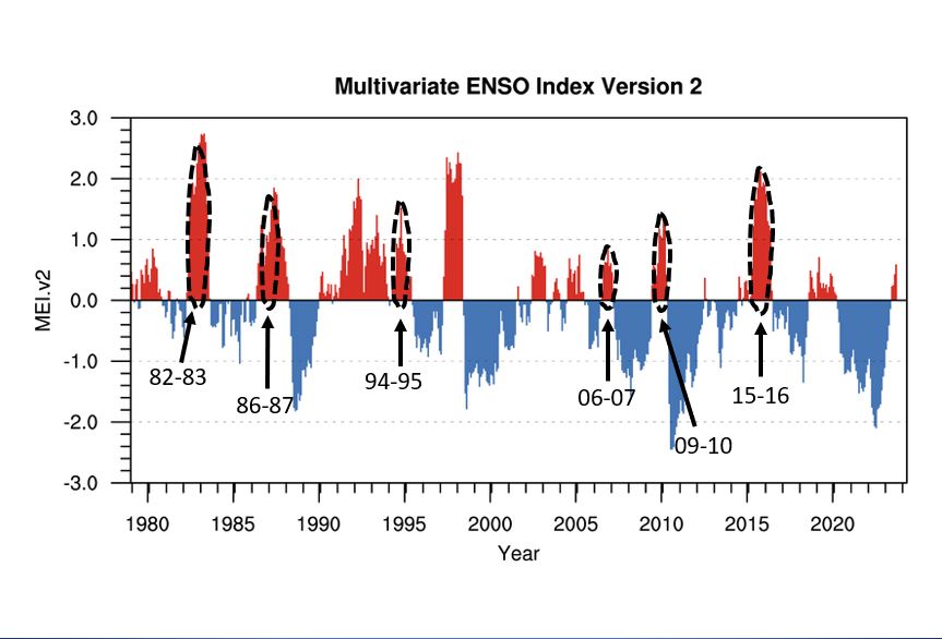
For those of you wondering how I create a winter forecast, the recipe is actually quite simple. I look at the distribution of temperature and precipitation patterns across the U.S. in past winters with similar conditions to those I expect in the upcoming winter. These are called "analog years," and they're a vital part of seasonal forecasting. This winter, I've chosen 1972-1973, 1982-1983, 1986-1987, 1994-1995, 2006-2007, 2009-2010, and 2015-2016 as my analogs (see below). In moderate-to-strong El Nino winters with an unstable SPV and the PDO in a transition phase (what I'm expecting this year), there tends to be an active, southern-branch storm track with a shift from rain/changeover storms through mid-January to more "all snow" events between ~January 20th and February 20th. Early on, storm systems tend to intensify too quickly and cut into the Great Lakes region. In addition, it often takes longer to build up a sufficient reservoir of cold air in Canada in comparison to ENSO-neutral winters. However, I foresee a weakening of the SPV later in December or January. If correct, this could lead to invasions of colder air masses into the eastern United States later in January and February. A truly Arctic air mass.. like the one we dealt with last Christmas.. may never impact the Commonwealth this winter. But, as the famous adage goes, "It doesn't have to be cold. It just has to be cold enough." Along these lines, I expect a couple opportunities for big, East Coast snowstorms, or Nor'easters, from late January through late February. Once the Jet Stream and overall storm track shift farther south, the mid-Atlantic States should more often be on the north/west side of coastal storm systems. These systems can readily tap into Atlantic and Gulf of Mexico moisture and produce crippling snowfalls on their northern and western flanks. If persistent, high-latitude (NAO/AO) blocking develops, there could be a few of these "big storms" like in February 2010. Without any blocking, a paralyzing snowstorm will become less likely.
Despite the threat for these larger and more impactful systems, total precipitation (rain, sleet, ice, and snow) from December - February will likely still only be near- to slightly above-normal. In between these bigger storms, there could and should be lengthy periods of quieter weather and weaker systems. As a whole, I am expecting 25-35" of snow this season in most of Lancaster County, with an above-normal chance of a major, double-digit snowstorm. A storm(s) of this magnitude will be most likely between ~January 20th and February 20th. Temperatures in December should be at least 3-5°F above normal, and the first half of January could also be quite mild. However, a transition should take place during the middle of January, with temperatures then averaging 1-3°F below normal from late January through February. In aggregate, temperatures should average around 1-3°F above normal this winter due primarily to a warm start. Despite this, snow-lovers should have much more to get excited about this winter in comparison to the last two.. -- Elliott