Department of Earth Sciences
Useful Links
- Millersville University Ocean Science Club
- AMS Journals Online: www.ametsoc.org.
CO-OPS
Career Links
- A good job link: www.usajobs.com.
- Career Opportunities at: Earthworks-Jobs.com
Past Features
DES faculty and students participate in WACS II
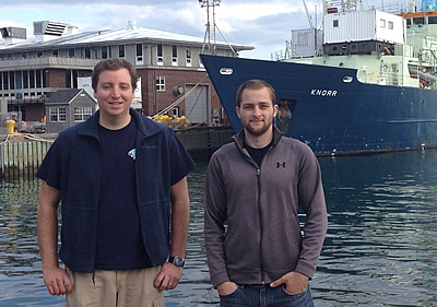
Dr. Robert Vaillancourt, Evan Ntonados (OSCS/MET) and Jeremiah Stone (BIOL/OSCS) participated in a NOAA-sponsored project, the West Atlantic Climate Study (WACS II) aboard the research vessel (RV) Knorr, a 279-foot global class research ship, from May 18 to June 7. The focus of WACS II was to determine the links between surface ocean phytoplankton and the production of freshly-emitted sea-spray aerosols, organic compounds produced by phytoplankton that are then ejected to the lower atmosphere and impact Earth’s climate by attenuating incoming solar radiation and providing cloud condensation nuclei. The multi-investigator study site extended from just south of Nova Scotia Canada to the waters around Bermuda, and was headed by NOAA scientist Dr. Patricia Quinn, of the Pacific Marine Environmental Laboratory, Seattle WA. The Millersville University contribution was to measure phytoplankton biomass and species composition in the ocean’s upper mixed layer.
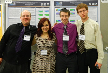
Ocean Sciences and Coastal Studies (OSCS) majors David Burcicki, Sigourney Stelma, Jeff Rafach and Russell Cool at the Ocean Sciences Conference , Salt Lake City, Utah, 2012.
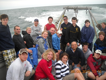
Students from the Field Methods class enjoy a break on the deck of RV Parker. Ocean Sciences and Coastal Studies (OSCS) majors are required to take field based classes (Like the one above) at the Chincoteague Bay Field Station (CBFS) during summer.
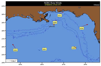
Nate Murry, (Ocean Sciences and Coastal Studies), is involved in a collaborative project with the University of Delaware & The Gulf of Mexico Research Initiative to determine the dispersal patterns of oil spilled during the Deepwater Horizon accident. He supported a recent research cruise in the Gulf by providing real-time analysis of wind & current data collected by Lagrangian ocean drifters deployed during the cruise. He continues to participate in on-going processing & analysis of oceanic data obtained by the drifters as well as from commercial oil platforms, NOAA ADCP units & NDBC buoys by developing code in MATLAB to create time series plots & vector animations aimed at determining how spilled oil disperses about the Gulf of Mexico & the ocean basin as a whole.
-
Contact Us

Department of Earth Sciences
Phone: 717-871-4359
Email: esci@millersville.edu